This walk's high point is one of the best panoramic views that I have seen in a long time, from Chalton windmill looking south across the Solent, or north deep into the South Downs. I want to acknowledge that I found this walk in Diana Pe's book, 'Hampshire and the Isle of Wight Church Walks', which includes 41 walks in Hampshire and 9 on the island. At the start and finish is a very fine pub the 'Red Lion', which is ideal for pre or post walk refreshment. The walk shows the very best of the South Downs and the hangars of Hampshire (the woods on the escarpments overhanging the valleys). There is some degree of climbing involved, and can be muddy in places. It is perfect as a summer walk - not so easy when raining. |
|
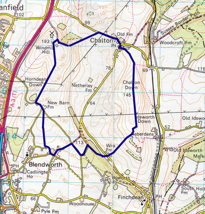
Distance: 9.3 km, 5.8 miles Walking Time: 2 hour 20 mins Difficulty: Moderate Wheelchair Accessible: No Start/End: Chalton, Waterlooville Access: |
 |
| Download printable Itinerary |
Download .gpx file |
Itinerary This walk starts in the centre of Chalton. To get there, head north up the A3/A3M and Chalton is signposted off to the left. It is approximately 20 minutes from Emsworth. At the centre of the village is the Red Lion pub, which is a useful refreshment point, and just beyond the pub there is a public car park on the right hand side. Opposite the pub walk up to the church through the lychgate, past the left hand side of the church, then on through two gates and into a large field where the path divides into three. At this point you are following the Staunton Way path, which is indicated and is the path to the right, heading south up the field. The path crosses three fields and beneath some pylons before coming to the edge of the third field. Just before the copse of trees, pass through the fence to your left and head round the copse to the left. After the copse, the wood opens up to a field on the right and there is a footpath indicated to the right heading south west along a track down the hill. Proceed right down the hill until you reach Wick Farm on your right hand side and cross over the lane. Head up Wick Hangar bearing right and heading north west. Continue to the top of the hill where the path comes out onto a quiet lane. Turn left on the lane, keeping the stables of the riding centre on your right hand side and keep going to a T-junction where you should turn right towards Blendworth along New Barn Farm Lane, again keeping the riding centre to your right. Continue along this lane until you reach a junction on your left where you turn south west again down to the village of Blendworth down Rowlands Castle Road. At the bottom of the hill you will find on the right hand side, the remains of St Giles Church, with a couple of seats and the old churchyard. Turn right here and then into Duckstile Lane. About 50m on, turn right onto a footpath that heads north across a field through a kissing gate. Follow this path to its end and turn left onto New Barn Farn Lane, where you reach New Barn Farm. At this junction, go straight and continue north west to where the road bears left, and then turn right into the footpath that heads north east up the hill. Follow this path for about a mile to the top of the hill where you find Chalton Windmill. Follow the path to the right behind the windmill, then after a short distance down the lane, turn sharp back on yourself down a narrow footpath shown on the right hand side. Follow this footpath on until it brings you to the top of a hill where the path leads down the steep hill across the middle of the field. This may be treacherous in wet weather so watch your footing. Cross the next field on the same footpath until you come to the road, where you turn right, and arrive back at the centre of Chalton. |
|