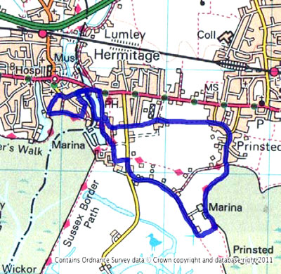
Itinerary
The walk starts from Emsworth Square. There is a pay-and-display car park in South Street.
From the square, head down South Street to the Quay.
At this point, so that you get your money's worth, take a quick look at the millpond - it is your first of the day.
From the quay you walk east along the southern foreshore of the village.
If it is high water, you may not be able to get along this frontage, but you will be able to see from here. If you cannot get along the foreshore, then return to the square, turn right into the High Street, walk straight down King Street and pick up the walk at Wharf House, the large Georgian House on the left, through two large gates.
Assuming you can get along the foreshore, then head east next to the sea wall until you reach a set of brick steps that leads up from the foreshore into The Fishermans road.
As you walk along the foreshore, if you look to your right you will see the remnants of two Emsworth industries of times gone by.
Firstly there are the remains of the oyster beds. Fishermen used to trawl small oysters called 'spats' in the English Channel, sometimes as far off as France. They would bring them back to Emsworth and place them in oyster beds to grow. After a couple of years they were large enough to harvest and sell.
You can also just make out some remains of some of the old boats built in Emsworth. At the end of the foreshore where you are walking was the Fosters shipyard, where numbers of fishing boats were built. You can learn more from the exhibits in Emsworth Museum in North Street next to the Fire Station.
Walk north up The Fishermans, then turn briefly right into King Street before turning left onto the footpath that passes in front of Wharf House through a pair of large gates. This path takes you down to Dolphin Quay. Follow the path to the left of the large gate and it bears left past the moored boats around the quay. Walk up to the junction with Queen Street and turn right to pass the Lord Raglan pub.
Just past the Lord Raglan, there is a path that goes through a new housing development to take you round the Slipper Millpond - your second of the day. Follow the path round the millpond to the far corner next to Slipper Mill.
This was a tidal flour mill. Today, the millpond is a bird sanctuary and wetland environment, and the mill has been converted into houses.
From here head south past the mill into Emsworth Yacht Harbour – your first marina.
This is a working marina so be careful of any machinery working.
Pass down in front of the boatsheds, and follow the edge of the marina in front of the new houses built on stilts.
This marina was built in 1964 on the site of the Fosters shipyard log pond. In Fosters day, they would float spars (masts booms etc.) in the log pond in order to season the wood.
After the first few 'stilt' houses, turn left and then right at the next footpath sign along Osprey Quay.
Look out for the footpath on the left that passes eastwards across the middle of a field. There are usually horses in this field.
At the end of the field path, turn right onto the road and walk about two hundred metres and turn left into Thornham Lane.
Walk down the full length of Thornham Lane and past the entrance to Thornham Marina on the left. Keep going past some bungalows, and then take the footpath on the left, which takes you down to Thorney Channel.
As you walk down Thorney Lane, depending on the direction of the wind, you might be aware that you are walking past the sewage works. With a northerly wind, you need to make it a brisk walk.
When you reach the end of the footpath next to the Prinsted foreshore, turn left and make your way back north towards the marina.
As you make your way along this path, you actually walk through the edge of the marina (your second of the day) and next to the pontoons. Possibly most notable in this marina is the large number of multi-hull yachts moored there.
Catamarans and Trimarans are often difficult to moor as marinas will charge double the charges of a monohull yacht, for obvious reasons. Here the marina is relatively shallow, which suits multihulls, and its position makes it more affordable.
Passing through the marina on the footpath, continue along the coast path up to the sea scout hut at Prinsted. Here come off the sea wall down through the car park and head north up Prinsted Lane.
Prinsted is a very small village, but is one of the most sought-after locations for a home in this part of Hampshire and West Sussex. Admire the homes as you walk up through the village - it has always been a very rich hamlet. The houses in the square date from the 17th and 18th century.
Prinsted takes its name from the fact that at one time there was a pear orchard there.
At the top of the lane, the road splits and you need to go left up the western side of Prinsted Lane. Keep going west. The road bears round to the right, but you want to branch off left to join the footpath that leads through a farm yard. Please be sure to close the large gate after you as you pass through and continue west between the fields.
At the end of this path, you pass between some horse barriers and come out onto the drives of the large houses on your left.
When you reach a T-junction, with the second large house on your left, the footpath continues west over a small bridge over a brook and then continues west beyond next to the brook.
The path then ends as you cross Thorney Road and continues west on the other side of the road.
Be very careful as you cross this road as it is very busy, because to the military camp down on Thorney Island. This road is the only means of access onto Thorney Island.
On the island is an airfield, now mostly disused that was very important during WW2 as a fighter base in the Battle of Britain. It is still used by the military for exercises, and you will find security around the camp strict.
Continuing west along the path on the other side of the road, it takes you through some fields and then down between some new houses and back to the Slipper Mill.
From here head north up the eastern side of the Slipper Millpond until you reach Main Road at the end. Turn left here past the top of the millpond, then bear left into Queen Street, past the Lord Raglan pub and keep going.
The road bears right into the High Street and you will find yourself back in the square – your starting point. |