This walk is a shorter exploration of the north part of Hayling Island, taking in the start of the Hayling Billy Line, but then branching over to the village of Northney with its picturesque and historic parish church, and its very own nature reserve.
This walk is good if you want a mix of sea and fields, as it takes in a good mix of both.
This part of Hayling Island is completely un-commercialised, and a hint of how the island used to be in days gone by. It is certainly a walk where you will need to bring your binoculars with you to watch the varied mix of sea-birds and land birds. |
Distance: 5.8 km, 3.6 miles
Walking Time: 1 hour 30 mins
Difficulty: Easy
Wheelchair Accessible: No
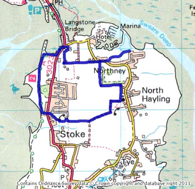
Start/End: Hayling Bridge car park
Access:
8 minutes drive from the Square in Emsworth
700 from Emsworth to Havant then 31 to Finiterre bus stop
|
 |
Itinerary
This walk starts at the amenity car park at the southern end of Hayling Bridge. To reach it from Emsworth, drive west onto the A27 then come off immediately onto the A3023 towards Hayling Island.
After passing over the bridge there is a small turning on the right which leads into the car park. If the car park is full, you can park the other side of the bridge in the car park adjacent to the Ship Inn.
From the southern entrance to the car park, follow the footpath west along the foreshore until you reach the line of the old railway, where you turn left.
Head south down the Hayling Billy trail, which is shared by cyclists, so be aware.
After about one kilometre, you arrive at a small car park, frequently used by windsurfers at high water. At the southern end of the car park turn left and head east along the approach road until you come to the A3023.
Turn right onto this road, and use the pedestrian crossing to cross to the other side and continue on the road south.
Just before you reach Mill Close, take the footpath signposted on the left hand side, which takes you round behind the houses. This then meets another path and you turn left and head east.
After about two hundred metres, the path ends behind the pumping station. Turn right over a stile and then immediately left, again over a stile. Keep going and continue to follow the path east.
The path now passes between open fields and joins a farm track which bears slightly left and continues up to a field boundary, where it turns left and heads north.
Keep following this track as it turns right at the top of the field and heads east.
Follow the track east, but when it takes a right hand turn, the footpath turns left into the churchyard of St Peter's Church, North Hayling.
This is a Norman church built in 1140 and is now the oldest church on the island
The church is in regular use, and they have built a very beautiful extension in the shape of an upturned boat on the rear.
Passing through the churchyard you cross over the approach road and re-join the footpath as it heads north along the eastern edge of a large field. At the corner of the field the turns left along the northern edge.
At the end, the path turns north along between a field on the left and a copse of trees on the right. Continue straight along this path until it meets Northney Road.
Turn right onto Northney Road and in about one hundred metres on the left hand side you will find a small car park for the nature reserve.
Cross the car park and walk into the nature reserve. Walk up the path and you will see Northney Marina on the left and Sweare Deep on the right. Explore as you wish, then return down the path, back through the car park and turn right on Northney Road.
Follow the road until it bears right - you follow the footpath that continues on westward down a farm track.
Follow this path until it stops and turns right and leads north to emerge at the petrol station. Cross the road (carefully as it is very busy) and you return to the car park where you started. |