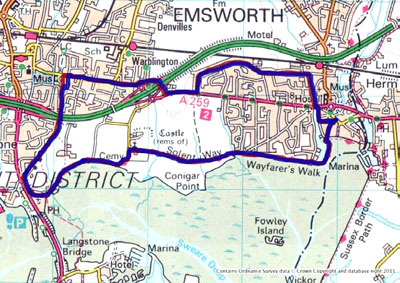
This walk is a variant of the Coffin Walk and takes a return route that goes via the centre of Havant.
Langstone is the furthermost point on this walk, and is a great example of the small ports around Chichester Harbour, and crucially is the link between Langstone and Chichester Harbours.
On the return leg from Langstone you follow the Hayling Billy line into Havant, and then follow roads back to Emsworth, giving you a chance to see some of the backstreets of the village.
Again a good one for a lunch trip to the pubs in Langstone. |
Itinerary
The walk starts from Emsworth Square. There is a pay-and-display car park in South Street, or a free car park in Bridge Road (just north of the main Havant Road).
From the square, walk south down South Street towards the harbour.
At the bottom of the road, you come across a small car park on the quay. Pass across this car park and along the pathway that leads out onto the breakwater surrounding the millpond. Walk around the millpond on this breakwater.
What you are walking around is a tidal mill pond that was used to drive the flour mill originally housed in the building that you passed that is now Emsworth Slipper Sailing Club. Tidal mills are common around Chichester Harbour, and worked by letting the millpond fill with the incoming tide and empty on the ebb tide, directing the water though sluices and a mechanism to drive the millstones. The Town Mill as it was called dates back to the 16th century
As you walk down the breakwater, if you look back at the southern foreshore of Emsworth, you will see the remains of the oyster beds that were once the centre of a famous industry in the 19th century.
At the end of the breakwater you will come to Emsworth Sailing Club. Pass behind the club on the footpath and go down onto the path along the foreshore. Follow this path right along in front of the houses until you reach a small bridge that crosses an outlet from some reed beds.
While walking down this path, keep a good lookout for the seabirds that feed along the foreshore. Depending on the time of year you can see all sorts of waders and gulls along this stretch.
After the bridge, the path splits. Follow the right hand path that goes along the back of Nore Barn Woods until you reach a kissing gate. Pass through this gate continuing westward, then through a second kissing gate onto a path that goes up the southern edge of a large field.
As you walk across this field, note the ruins of a tower ahead and slightly to the right of the path. These are the remains of Warblington Castle. This is private,so you cannot get to see the grounds, but Warblington Castle was the home of the Blessed Margaret Pole, who was executed by Henry VIII in 1541
At the far side of the field, pass though another pair of kissing gates and come along next to Warblington Cemetery.
Just past the new cemetery extension on your right, you come past Warblington Church. Before the church was built in Emsworth, this was the main church for the area, and the route you have just come is known locally as the coffin walk, as this was the way people had to carry the coffins from Emsworth for burial in the churchyard.
The churchyard is interesting as it contains a guardhouse to guard against body snatchers. Also the Yew trees in the churchyard are centuries old. It is worth taking time out to go into the church when it is open.
Following the footpath past the church, you continue directly westward into Warblington Cemetery via a kissing gate.
Pass through the the far side of the cemetery where you turn left, and then walk down to another kissing gate on your right, which takes you diagonally across a field to the foreshore.
At the foreshore, turn right and walk along the footpath.
If the tide is up, for the next section where the bank is supported by railway sleepers you will need to take the footpath above the sleepers if you want to avoid getting your feet wet.
These sleepers were originally part of the Hayling Billy line, the railway that connected Hayling Island with Havant. The line is now a leisure path.
At the end of this section you climb up onto a path along the side of another millpond, now a wetland nature reserve. However, you can see the locks and sluices as you walk round behind the old windmill.
Follow the foreshore path past the Royal Oak pub and turn right into Langstone High Street.
The Royal Oak and a hundred metres along the foreshore the Ship Inn; both of these pubs serve a great drink and good food, so if you are looking for a break half way along, this is your chance.
Walk to the end of Langstone High Street and turn right onto the main road onto Hayling Island, the A3023. About a hundred metres north on the right hand side you will find the Hayling Billy line path that forks off to the right. Proceed up the path.
The Hayling Billy line was the main railway connection for people travelling to Hayling for their holiday. It was closed following the Beeching report in the 1960s, and has now been made into a leisure path for walkers, cyclists and horse riders.
Just before you cross into the car park next to the Emsworth Road, turn right back on yourself and follow the path for a short distance before turning north into Lymbourn Road. At the end of Lymbourn Road, turn right into Emsworth Road and cross over to the path on the northern side of the road.
Continue along this road, crossing a couple of sideroads until you come up to the roundabout on the main A27.
Just before the roundabout, bear left into Castle Avenue, bearing right takes you down to an underpass under the A27 and out onto Havant Road on the other side.
Follow the Havant Road to the left towards Emsworth.
If your legs have had enough at this point, you can continue right along the Havant Road into Emsworth and back to the beginning. If not...
Turn left into Selangor Avenue and follow the road round as it turns into Victoria Road and brings you through the northern part of South Emsworth.
The bungalows and houses along this road are typical of the type of housing built up when Emsworth started to grow in the 1930s and 40s. As you go on, you fringe a council estate in Bosmere Gardens.
After walking about a kilometre along Selangor Avenue/Victoria Road, you will come across Bridge Road on the right hand side. Head down Bridge Road to its T-junction with Havant Road.
To the left of you as you walk down Bridge Road is the river Ems. While most of the time this is more of a brook than a river, the southern end of this road is prone to flooding if the water cannot clear down quickly into the millpond. There was serious flooding here in 2010.
At the junction with Havant Road, turn left to the pedestrian crossing lights, and cross over Havant Road.
Turn right briefly on the other side, then turn left down Bridgefoot Path along the side of the millpond.
Take the second left off this road into Nile Street, which brings you back up to Emsworth Square and your starting point for the walk. |