This walk is definitely for the bird watches among you. It is local Nature Reserve and adjacent to RSPB reserves. A must for your binoculars.
The walk goes around a peninsular of land that is immediately adjacent to the M27, and which projects out into Langstone Harbour. It is a strange mixture on the northern side with traffic incessantly charging down the motorway, yet a few yards along the path and you find yourself in the midst of a nature reserve and a wealth of wildlife.
Langstone Harbour is interesting because unlike Portsmouth and Chichester harbours, it is little used (and sometimes neglected) but the nature is striking. Enjoy. |
Distance: 4.3 km, 2.7 miles
Walking Time: 1 hour 15 mins
Difficulty: Easy
Wheelchair Accessible: No
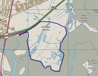
Start/End: Farlington Marshes car park
Access:
10 minutes drive from the Square in Emsworth
700 from Emsworth to Havant then 23 to Rectory Avenue then 21 to Walton Road |
 |
Itinerary
The walk starts from the car park for Farlington Marshes. To get there from Emsworth, head west out of the village along Havant Road and join the A27 towards Portsmouth. This turns into the M27, and you need to leave on the second exit heading west, signposted for the A2030 into Portsmouth.
As you come down to the roundabout at the end of the sliproad, stay in the left hand lane and immediately after the traffic lights, actually on the roundabout, turn left into the car park. There are three parking areas so if the first is full just carry on. The second is the largest, and the directions are from this car park.
From the car park, climb down the bank to the concrete footpath alongside the foreshore and head east.
You are walking along the sea wall, and virtually all of Farlington Marshes lies below sea level. It was reclaimed from the sea in 1771.
The purpose of reclaiming land is not entirely clear, but in the 19th century, fresh water springs on the marshes were used to supply the city of Portsmouth.
Before that, the marshes were a favoured area to hunt wildfowl, and given the date, it is possible that the aim was to create saltings, for the production of salt.
Since 1961, the marshes have been a nature reserve managed by the Hampshire and Isle of Wight Wildlife Trust.
The footpath swings up to the left, follow it then turn right through the kissing gate into Nature Reserve and head south.
Follow the path straight, rather than going up to the foreshore as it takes you through the marsh itself until you reach a second kissing gate and come up to the path along the top of the sea wall.
It is sometimes hard to know which way to look to spot the wildlife, and particularly the birds. As you walk round the sea wall you will find observation points, looking inward to the wetlands in the marshes.
Keep to the path as it follows the sea wall right round the peninsular to its eastern side where you will find yourself walking north.
As you turn at the most south-easterly point, you will see a strange mound out on the mudflats.
This is the site of the 'oyster house'. This was a guard house for the oyster beds.
The oyster industry was very important in both the northern part of Chichester Harbour, but also right down the western coast of Hayling Island.
From this vantage point, all the oyster beds along the north western corner of Hayling Island can be observed.
Just as you see the RSPB reserve appearing on the mudflats, you will see a clear path heading west inland. Turn left onto the path. After about 250 metres, turn left onto another path, which leads past the visitor centre and its wind generator.
Follow the path until it reaches the cycle path running along next to the M27, and turn left along the path.
At the end of the path, continue along the road, which takes you back you the car parks and where you started. |