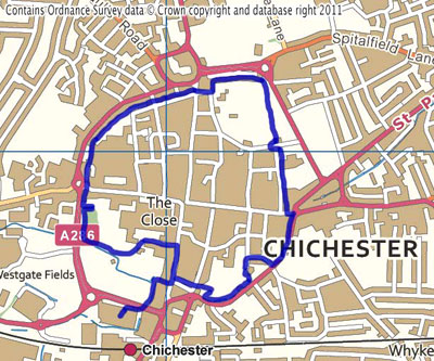
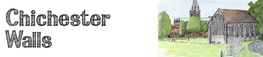
When was the last time you walked the entire circumference of medieval city walls? - there aren't many left, but the walls in Chichester are amazing.
The walk along the walls is not only drenched in history, but gives you a peek into the initmate secret backstreets and backyards of a truly wonderful city.
You can combine the walk with a shopping trip in this picturesque county town of West Sussex, or a lunch in one of the many eateries in Chichester. It is hard to overstate how pleasant this walk is, with such a wealth of parks and nature combined with the mix of ancient houses and public buildings - how lucky are those people that live there! |
Itinerary
This walk starts from the multi-storey car park in Avenue De Chartres.
From Emsworth take either the A27 or A259 east until they come to the Fishbourne roundabout where you head north to towards the city centre. Continue over two roundabouts and the car park entrance is off the third roundabout.
From the first floor of the car park head west along the walkway, then cross the road over the footbridge heading north west. The path then goes down a ramp into Deanery Close.
You will see a black sign at the bottom of the ramp indicating the walls to the left. We are going on a more exciting route, but if you want to see the Palace Bastion, you can follow the sign and catch up with the walk after the Bishop's Palace Garden.
From the bottom of the ramp, turn right and walk through to South Street where you turn left and towards the Market Cross in the middle of the city.
If you want to pick up any extra information or maps, the Tourist Information office is on your left. There is a guide to the Walls Walk published by the Chichester Walls Walk Trust to buy here.
About half way up South Street heading north to the cross you will see Canon Lane leading through a large gateway on the left hand side.
Canon Lane is part of the precincts to St Richard's Cathedral, and you can turn right for an excursion off Canon Lane into the Cathedral if you wish.
The Cathedral is the seat of the Anglican Bishop of Chichester, and was founded in 1075, when the bishop moved from Selsey to Chichester.
St Richards has two architectural features that are unique among England's medieval cathedrals - a free-standing medieval bell tower or campanile, and double aisles.
The cathedral contains two rare medieval sculptures, and many modern art works including tapestries, stained glass and sculpture. There is one very striking stained glass window by Marc Chagall.
Go down Canon Lane until you reach another large gateway at the western end. Pass through the gate and immediately turn left into the Bishop's Palace Garden.
You walk through a narrow walled garden before emerging into the main gardens, where you immediately turn left and up the steps and onto the top of the walls.
The City Walls are approximately 2.4km, 1.5 miles in circumference, and date back over 1,500 years, although the walls we see today are probably more like those that were rebuilt in 14th century.
The walls originally had a series of bastions, and walking along this path, you will come across the top of the Palace Bastion, which is one of the few remaining.
Walk right along the top of the walls, and at the end, walk down into the main part of the garden and come out through a doorway in the wall.
Turn towards the road, then turn right up the pavement to Westgate Roundabout.
This is the site of the original Roman gate that led from here to the port at Fishbourne where a Roman Palace has been found. It was the main sea port in Roman time in the mid-south coast.
There is a pavement that passes the right hand side of the roundabout and leads you north into North Walls. Follow North Walls for about 60 metres before bearing left and coming up on top of the walls again.
As you walk along this section of the walls you get the chance to peek into the gardens and back yards to the houses backing onto the walls. Perhaps for this very reason, they are particularly well kept.
On your right you will pass the offices of West Sussex County Council.
Follow the path along the top of the walls round until you are heading east, and the paths slopes down to North Street.
Cross straight over North Street into Priory Lane and follow the black sign to the walls ahead. The road turns right, but you turn left through a doorway into Priory Park and climb back up to the path along the top of the walls.
As you walk round, you can again peek into the gardens of the houses against the walls, but also notice the huge variety of trees around you.
On your right as you come into the park, you will see a somewhat neglected mound of earth. This is the remains of the castle of Earl Roger de Montgomery, who came over with William the Conqueror in 1066 and built his castle here.
Moving round, you look back onto the park, you will see the City Guildhall, which is a 13th century building, built as the chancel by the Grey Friars. At the dissolution of the monasteries in 1538 the building became the Guildhall.
The building is an aisle-less structure, 25m by 9.4m with a height of 13m. The western wall was a later addition, leading to the belief that some portion on the nave must have at least been begun.
Follow the path around the park until you are heading south. At the end, the path swings down and round to the right then through a gate and out of the park.
Turn left, then cross the road to ascend the steps that take you up to the top of the next section of walls.
On the right hand side as you pass down this section of wall, you can see a large flint building which was the former Drill Hall of the Sussex Yeomanry.
Follow the walls continuing south until these ramp down to the end of East Street.
On the right hand side as you pass down the ramp you will see a development of residential housing, which has been built on the site of the Shippams factory. Shippams made fish and meat paste, and moved out of the centre of town in 2002.
This bit is a bit confusing as you cross East Street and turn left following the black sign to the walls. Confusing because it is the last sign you see for a good bit.
Follow the pavement as it bears right into Market Road. You will see the market car park on the other side of the road, but keep going until your reach a turning off to the right next to a car park against the walls. This road is signposted to the 'District Council Office'.
Follow the road round to the left, signposted as parking for the District Offices and go to the end, cross Friary Lane and go into the car park on the left.
From here you will be able to see a large black sign showing the path back onto the top of the walls.
This part of the city was formerly the Domenican Friary suppressed in 1538. The land was not developed until the early 19th century, when it was broken up into building plots.
Follow the path, which eventually turn back on itself and brings you out onto the other end of the car park.
From here head west out of the car park and across the road to Theatre Lane that leads you back to South Street.
Turn left onto South Street and you will be able to retrace your steps down next to the Slug and Lettuce, back over the bridge to the car park where you started. |